Favorite Trails
The 1.6 million acre Deschutes National Forest is our backyard, providing endless opportunities to soak in the great outdoors. A Northwest Forest Pass may be required at the parking areas. The pass costs $5 per day or $30 per season. It can be purchased at a ranger station, an outdoor store or at the trailhead fee box. For additional hiking ideas, visit these sites: Sisters Country | Deschutes Land Trust guided hikes | AllTrails | Sisters Trails Alliance
Local Favorite Hikes
Black Butte Lookout
Hike BBR’s namesake in this 3.6 mile, 1,556 foot climb. Views of Cascade peaks and BBR await at the summit.
Route #1 From BBR: drive east on Hwy 20 to Indian Ford Campground, near MP 95. Road is rough, but doable. Turn north onto paved Green Ridge Road 11. After 3.8 miles, turn left onto gravel Road 1110 for 5.1 miles to a parking area at the road’s end.
Route #2 Want more of a challenge? Try the historic Black Butte Trail # 4026. From BBR, turn west on Hwy 20 for 2 miles and turn north on FS 14, SW Camp Sherman Road. Park at the trailhead on the right, just past the “Y”. This 9.8 mile out and back trail features wild flowers.
Metolius River & Camp Sherman
The Metolius River boasts blue waters and lush forests. From the Headwaters of the Metolius (where it springs from the ground) to the Wizard Falls Fish Hatchery, the trails are mostly flat. Stop by the Camp Sherman Store for a treat. The Metolius River Preserve is a beautiful area along Lake Creek protected by the Deschutes Land Trust.
From BBR: take Hwy 20 west 2 miles, turn right at the Camp Sherman. Follow FS 14 to a fork and bear right. Continue 7.5 miles, turn left at the Fish Hatchery.
Headwaters of the Metolius
While you’re exploring Wizard Falls Fish Hatchery, take a small detour to the headwaters of the Metolius. It’s only a 1/2 mile round trip on a paved foot path with a glimpse of the headwaters & a wonderful view of Mt. Jefferson. A great outing for anyone with limited mobility.
From Black Butte Ranch: take Hwy 20 west 2 miles, then turn right at the Camp Sherman turnoff. Follow Road 14 for three miles, then turn right & continue 1.5 miles to the Head of the Metolius parking area.
Suttle Lake Trail
This flat 3.6-mile trail winds along the forested shore of Suttle Lake with views of Black Butte and Mt. Washington. Just above Suttle Lake is Scout Lake, a shallow, family friendly swimming hole for a warm summer day.
From BBR, take Hwy 20 west 5 miles to the Suttle Lake Campgrounds. Access the trail from several points, including Cinder Beach near Suttle Lake Resort.
Sisters Tie Trail
Run, hike or bike on a trail that is a mix of old roads and single track, and it runs 6.6 miles one-way with access points along its length. There is no water available on this trail, so be sure to bring your own.
From BBR, take Hwy 20 west to Road 2060 (George McAllister Rd.) and turn left. Park near the intersection with Hwy 20.
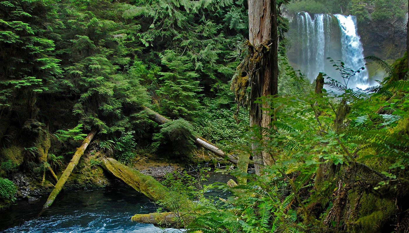
McKenzie River Waterfalls
The McKenzie River Trail offers a 3-mile loop with beautiful forests and views of Sahalie and Koosah Falls. Stop at the headwaters at Clear Lake to see the the preserved forest on the lake bottom.
From BBR, head west 18 miles on Hwy 20. Take a left at the Santiam “Y” to stay on Hwy 20, then turn left on Hwy 126 toward Eugene. Turn right at the sign for Sahalie Falls.
Hwy 242 (open seasonally) is another option for sightseeing. Turn on Hwy 126 to visit the waterfalls and Clear Lake before returning to the Ranch via Hwy 22.
Proxy Falls
This easy loop trail of 1.25 miles to two waterfalls, one of the most photographed spots in Oregon.
From Sisters, at the roundabout, take the first exit onto McKinney Butte Rd. Turn right on Hwy 242 (open seasonally) for 26.6 miles. When Hwy 242 is closed, access the falls via Hwy 126 across from Belknap Hot Springs.
Whychus Creek/Upper Chush Falls
The falls on Whychus Creek are a local wonder, but the drive to get there can be an adventure of its own. Once you get to the area, there are several cascades, but Upper Chush Falls is the largest with a 225 foot descent. Take a four-wheel drive vehicle with good clearance. You’re likely to get some scratches from encroaching brush.
From Black Butte Ranch: head east on Hwy 20 to Sisters. Turn right on Elm Street toward Three Creeks Lake. Drive about seven miles and turn right (west) on Forest Road 1514. Drive five miles to Forest Road 1514-600 & follow 2 miles to a T. Bear left to the Chush Falls Trail.
Whychus Creek Overlook Trail
The Whychus Creek Scenic Overlook sits perched atop cliffs overlooking Whychus Creek. Reached via a 1-mile accessible trail, the overlook offers expansive views of the Whychus Creek Wild and Scenic River area, as well as, the Three Sisters’ peaks.
Visitors have two options to reach the overlook. The easier out-and-back South Trail winds through the forest before reaching the overlook. A more difficult North Trail turns the hike into a loop, but features sustained hill climbs and a longer distance. However, the North Trail does offer two additional mountain viewpoints before you reach the overlook. Those who choose to take the North Trail will return to the trailhead via the South Trail, as the North Trail is one-way only.
From Sisters, turn south on Elm Street / Three Creek Road /FS16 and travel 5 miles. Trailhead will be on your right.
Download a trail map.
Three Creeks Lake Area
Three Creeks Lake has many options to explore: from the steep, 4.5 mile-Tam McArthur Rim to the 3-mile mountain meadow retreat of Little Three Creeks Lake. The Little Three Creek Lake Trail is an easy loop hike to Little Three Creeks Lake with nice views of the Sisters Mountains.
The Peterson Ridge Trails (biking) and the Whychus Overlook Trail are also accessed from FS 16. Three Creeks Sno Park provides winter hiking, skiing and snowshoeing.
From Sisters, turn right on Elm Street, which will turn into FS 16 to Three Creeks Lake. (The pavement ends after 15 miles). Turn right at the Driftwood Campground. Tam McArthur Rim: across the stream from the parking area by the main road. Little Three Creeks begins at the end of the gravel road.
Dee Wright Observatory
Dee Wright Observatory is an observation structure at the summit of McKenzie Pass on Hwy 242 (open seasonally). The structure is an open shelter constructed with lava stone. It is located in the midst of a large lava flow, and offers an exceptional view of numerous Cascade peaks. Short trails offer great views of the Sisters Mountains.
On the Cascade Range at 5,187 feet, this mountain observatory offers panoramic views of the Mount Washington and Three Sisters Wilderness areas.
From Sisters, OR travel west on Hwy 242 for 15 miles to the Dee Wright Observatory. (Hwy 242 is open seasonally.) The observatory will be visible from the highway, and parking is immediately available.
Pretty river canyon walk along the Deschutes River. Start at Tumalo State Park or Riley Ranch.
HWY 126
Tamolitch Blue Pool – Popular, easy hike to a beautiful blue pool at the base of a usually dry waterfall on the McKenzie River.
Clear Lake – Resort with cabins and boats to rent. Through the clear water that is the headwaters of the McKenzie River, you can see standing old growth trees on the lake bottom. The walk around the lake is particularly beautiful in Fall.
Fish Lake – Remount Station
SOUTH OF SISTERS
Peterson Ridge Trails/Eagle Rock (mostly for biking)
Three Creek Sno-Park (winter hiking, cross country skiing and snowshoeing)
HWY 20 WEST
Potato Hill (cross country skiing, hiking, snow-shoeing)
Iron Mountain/Cone Peak (wildflowers, views) – A favorite wild flower hike in July.
REDMOND/TERREBONNE
Smith Rock – A state park with interesting rock formations and a great river walk along the Crooked River. Also a favorite of rock climbers.